
General Information
 Shelburne Falls for the First-Time Visitor
Shelburne Falls is the business district shared by the towns of Buckland and Shelburne. Once a prime Salmon fishing spot for native Americans, the village gradually emerged more than a century ago as a manufacturing community centered around industry on the Deerfield River. The village experienced a revitalization in the 1980s and 1990s, and unlike many similar communities, evolved and continues to be a vital downtown with a growing reputation as an arts community.
The village resisted the "urban renewal" trend of the 1950s and 1960s, which has left our generation with an historic, turn-of-the-century setting for a unique mix of locally owned businesses.
It's a village where you can buy either a head of iceberg lettuce or a hand-blown glass vase!
Shelburne Falls is home to the world-famous Bridge of Flowers, which attracts more than 35,000 visitors a year, as well as the Glacial Potholes, a curiously beautiful rock formation. The Shelburne Falls Trolley Museum celebrates the village's transportation heritage.
Most everything in the village is within walking distance, so if you're planning to spend some time in the village—and we hope you do!—we encourage you to park in one of the free public parking lots off Bridge Street. (Follow the Parking signs, or see the location on the village map.)
Health Services
Medical Emergencies: call 9-1-1 anywhere in Franklin County.
Hospital
Baystate Franklin Medical Center
413-773-0211
164 High Street
Greenfield, MA
Public Phones
Pay phones are located outside:
- Buckland Neighbors
- Davenport's Mobil Station
Public Restrooms
Public restrooms are available during open hours in the:
- Buckland Town Hall, 17 State Street, Buckland side of the Iron Bridge
- Hearty Eats, 24 Bridge Street
- McCusker's Market's Deli, 3 State Street, Buckland side of the Iron Bridge
- Mocha Maya's, 47 Bridge Street
- Shelburne Town Hall, Memorial Hall, Bridge Street
- Shelburne Falls Trolley Museum, Buckland rail yard, end of Depot Street
- Village Information Center, 75 Bridge Street
Directions and Parking
Parking is free throughout town.
From the East: Follow Route 2 for 12 miles from the Greenfield Interstate 91 rotary (Exit 26). Turn at the sign "2A West, Shelburne Falls, Buckland", by the Sweetheart Restaurant. Another quick left, following the "2A West" sign, brings you to Bridge Street. Drop by the Village Information Center at 75 Bridge Street, across the street from People's United Bank.
From the West: Turn at the "2A East, Shelburne Falls" sign onto State Street for .6 of a mile into the Buckland side of the village. Additional parking is available up the hill toward the Salmon Falls Artisans Showroom. On your left, just before the railroad tracks, is a large parking area; follow the signs.
Parking: There is free parking on Bridge Street (the main street through the village). Free parking is conveniently located in many areas throughout the town.

The Village Information Center
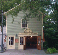 The Village Information Center, located at 75 Bridge Street, is open from May 1 - October 31st, Monday - Saturday 10 AM - 4 PM and Sundays 12 PM - 3PM. Find information about local attractions, events, restaurants, and lodging. Accessible restrooms and internet access are available.